Route Notes
The following is intended as guide to the ground covered along with some idea of the distances and amount of ascent/descent involved. Clicking/tapping on anything in a cartouche like this will show a dialog, usually info but could be a form like the calculator. The times in the précis are very rough and include stops. They give a round of roughly 23hrs. The notes reflect the options you choose in the calculator but defaults to midnight on the closest Saturday to the next midsummer’s day.
Click on the section headings to toggle between the précis and a complete set of notes. The right-hand border of the full notes indicates the daylight status for that section according to your chosen Route options are presented left to right as you approach them.
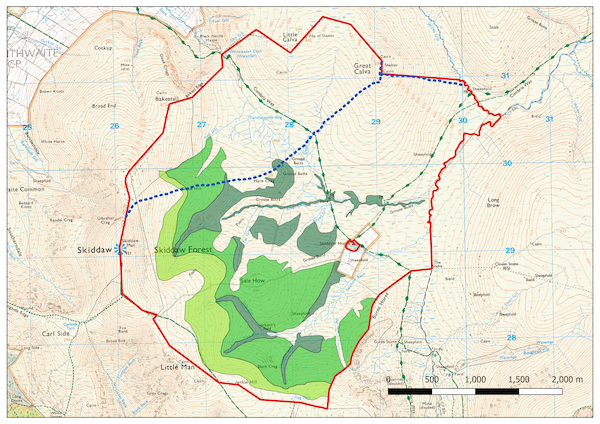
⇅ Section One: Keswick to Threlkeld
A short amount of road to the small carpark on Latrigg then a steep pull up onto Skiddaw itself. A steep descent to the track leading to Skiddaw House, straight over this and up Great Calva, then a beeline for Blencathra. Finally a descent of the steep Halls Fell to Threlkeld. Once on the fells the going is at first a slate/shale path then boggy or heathery with a rocky final descent.
Distance: 12.5 miles, Ascent: c.5150ft, Time: 4hrs
Leave the Moot Hall and cut through one of the ginnels to the central car park. Cross to the main road and take the road to the left of Keswick Cycles. About 50m along this there is a footpath to the left. This leads to the footbridge over the river Greta into Fitz Park. From here go diagonally left across the park and through the wood by the path.
At the road turn right and in 100m turn left onto a bridleway, this crosses the A66 via bridge. Follow the bridleway as it winds upwards around Latrigg to join the road to the carpark at (GR: NY280253). From here, follow the motorway of a path to the summit of Skiddaw.
Note that the next section may be subject to change as the tree planting as part of the Skiddaw Forest rewilding project. The proposed area covers the route from about 1km before Skiddaw summit, over Great Calva and as far as the River Caldew. Any on-the-ground directions should be followed in preference to these notes.
Continue in the same line to (GR: NY263296) then cut down right and cross the fence at a stile to gain a path that joins a set of quad-bike tracks. When these begin to bear left, cut to the right on a prominent path which leads over Hare Crag to the Skiddaw House track at a small bridge (GR: NY283303). From the road crossing follow the beck on the righthand side for a hundred metres or so:
- Continue directly towards the summit of Great Calva from the head of the beck via a path through the heather. This bears rightwards as the ground steepens to join the path on the ridge.
- Bear right along a faint track to gain the main path on the ridge. There is a solitary fence post on the ridge at this point. Follow this to the summit of Great Calva (MB-050).
From the south end of the summit plateau there are a number of alternatives:
- Descend by the fence line heading NE into Wiley Gill. Follow this down to the Caldew, cross and continue in the same direction onto Mungrisedale Common. This will likely follow the boundary of the rewilding project.
- Follow a bearing of (MB-147) through increasingly high heather to gain the bridleway/track. (Alternative) A couple of hundred metres of very rough ground leads to the River Caldew at around (GR: NY296297) at the big bend in the river. There is a sheepfold on the other bank about 200m from the river (not marked on the OS map). If the river is in spate, then head upstream until the fence crosses the river and use this.
- Descend the south ridge of Great Calva and join the vehicle track leading to Skiddaw House. From here continue SE on the bridleway to the watershed then head E to climb to the Cloven Stone from where a faint path leads to Mungrisedale Common. Longer but less height loss and the only viable option if the Caldew is in flood.
Once on Mungrisedale Common head for Atkinson Pike (GR: NY32322827) at the eastern end of Blencathra. Take care not to veer too far to the right, you need to aim for the left end of the summit skyline (MB-117). Just before the ground steepens there is another sheepfold on the left (again not marked on OS map) and the path fades away. About 200m after the fold, bear right finding the best way through the screes, then in the same line to the summit of Blencathra at the top of Hall’s Fell Ridge.
There are now several options. From left to right as you approach them:
- Doddick Fell
- This provides a less exposed but longer descent. Preferable if conditions are poor when Hall’s Fell can be time consuming. Head East from the summit and descend on a good path to a small cairn just after the second set of zig-zags (GR: NY32802775). Now follow the path down to the valley and traverse back west to the fell gate.
- Hall’s Fell
- Descend this (MB-154), there is some exposed scrambling after a couple of hundred metres. Follow the path down the broader lower slopes before bearing right to the fell gate.
- Traverse into Hall’s Fell
- Start down the gully to the west of Hall’s Fell but after a few metres make a descending traverse leftwards to join it below the scrambling section.
- Middle Tongue (The Parachute Descent)
- The gully to the west of Hall’s Fell may be descended, but should definitely be recconoitred first as it is not well marked on the ground and the route finding is quite involved. It is very steep, losing virtually all of the elevation in around half the distance taken on Hall’s Fell.
From the fell gate at (GR: NY325263) go straight down the bridleway, past a farmyard, to the minor road, follow this down to the A66.
Parking notes
⇅ Section Two: Threlkeld to Dunmail Raise
A slightly involved section in the valley to gain the slopes of Clough Head, once the summit of this is reached then it is high level ridge running along mainly grassy paths to Helvellyn. At Dollywaggon Pike a steep descent is made to Grisedale Tarn then the two outliers of Fairfield and Seat Sandal are taken before descending to the road at the summit of Dunmail Raise. The going is mainly grassy with some easy stony paths around Helvellyn and Fairfield.
Distance: 13.2 miles, Ascent: c.5900ft, Time 4hrs
Cross the A66 and take a small road (GR: NY325254) that leads down to the River Greta and crosses it at Mill Bridge. The continuation of the road is open to the public so carry on to Newsham House (GR: NY331247) but before the house take the gate on the right to the open fell.
Skirt the woods on the right. Go through the gate and follow a path, faint at first, that parallels the wire fence (on your left) until a track (The Old Coach Road) is reached that traverses the hillside. Now head straight up the front face of Clough Head, keeping to the right of an obvious shallow gully. Eventually the ground steepens and a faint track appears leading up to the summit ridge. Turn right and go up to the summit of Clough Head.
The path in general is well defined from now on and the running is good. Head towards Calfhow Pike (MB-194) and from there towards Great Dodd (MB-143 to Little Dodd then MB-077). From the summit of Great Dodd head south west until the ground levels out.
At the first slight rise a faint track heads rightwards (MB-251) to Watson’s Dodd. A further faint track leads back to the main path just before the rise to Stybarrow Dodd. The main path contours round the summit area so head up left to the summit cairn. From the cairn, do not go to the cairn to the SW, but aim in a straight line to the left of this and drop down to join a good, wide, path that descends to Sticks Pass. This continues to rise until the ground becomes rocky, where a path winds its way in the same general line to the summit of Raise.
The track turns right on the summit of Raise and is faint for a while but then good paths lead to White Side where a sharp left is made, then up to Helvellyn Lower Man and on to the top of Helvellyn.
Turn due south and follow the motorway of a path until a junction at the first col, take the left branch and climb up onto the flanks of Nethermost Pike. The summit is the second of two cairned tops that can be seen from the main path.
From the summit take the grassiest route back to the main path and drop into the col. Where the main path skirts round to the right, keep close to the edge on the left and go over a rocky rise before climbing up to the summit of Dollywaggon Pike.
Keep close to the edge again where it is grassiest and head in a southerly direction to gain the top of the zig-zags.
- Option 1
- There is a single fence post (actually an old gate post for the path to pass through the long-gone boundary fence) (GR: NY345128) on the right that marks the line of an old fence. In the ground can be seen a groove which is the line taken by the fence. Follow this down, keeping to the right of the wall in the lower section, to the path that follows Raise Beck from Dunmail to Grisedale Tarn. Go round the obvious track on the far side of the tarn to Hause Gap, the col between Fairfield and Seat Sandal. Leave sacks and bum-bags here (there is an old bield) and climb the scree slope to Fairfield.
- Option 2
- Go down the main track (or better the grassy slopes to the side) to the outflow of Grizedale Tarn. Take the path leading to Deepdale Hause, the col between Fairfield and St Sunday Crag. At the col turn right and follow the path on the ridge to the Fairfield summit plateau.
- Option 3
- As for option 2 down to the outflow of Grizedale Tarn and take the path to the col between Fairfield and St Sunday Crag until a beck is crossed then directly up the scree to the Fairfield summit plateau.
From the summit of Fairfield head down the screes to Hause Gap before climbing the ridge to follow the obvious path up the scree to an easing in the angle to the summit of Seat Sandal.
Take a line towards the north end of Steel Fell (MB-293) to a patch of reeds on the top of the steep part of the ridge to gain a that leads the lower end of the path dropping down by Raise Beck and so to Dunmail Raise.
Parking notes
⇅ Section Three: Dunmail Raise to Wasdale
This is the longest section and generally the roughest underfoot. A steep climb from the road to Steel Fell leads to an undulating section in and around rocky hummocks to the Langdale Pikes. A moorland section then leads round the head of Langdale to Rossett Pike. A cunning scramble leads to Bowfell which marks the start of the roughest section of the round. Speed is difficult to maintain over this terrain as it is mainly composed of large boulders. Eventually Scafell Pike is reached. The quickest way to Scafell is via Broad Stand which is a rock climb, though admittedly easy, where a rope may be required (support team?). It is then a long descent on grass to the car park at Wasdale.
Distance: 15.2 miles, Ascent: c.6500ft, Time 7hrs
There are two shallow gullies descending from Steel Fell. The left hand one is directly in front of you as you cross the stile. Head straight up this to the summit ridge. (GR: NY322116). An intermitently defined path leads left to the top of Steel Fell. (There is a boundary fence along the ridge to follow if the weather is misty.)
Follow the path next to the fence, moving left to avoid a small crag at one point just after a bog bridged by some old fence posts. When the fence turns 90 degrees to the right, continue in the same line on the well defined path that keeps straight ahead past soft/boggy ground before bearing left to Calf Crag.
A good path leads to the pass at top of Far Easedale. Straight on over the “crossroads” with the Greenup Edge path, following the vague path that follows a line of old fence posts.
There’s the only choice to alter the order of tops visited here…
- High Raise
- A hundred metres or so beyond the Greenup Edge path bear right to the open gully to the east of Birks Gill, keep left in this to cross over the slight ridge into the top of Birks Gill. Now head SW to High Raise.
- A good path leads in almost a straight line (MB-145) over sometimes boggy ground to Sergeant Man.
- Sergeant Man
- The path keeps to the left of the beck, (good water source) at one point heading up a subsidiary gully well to the left. The posts stop around 200m short (GR: NY289091) of Sergeant Man, straight on to this.
- Good path leads in almost a straight line (MB-325) over sometimes boggy ground to High Raise.
From either top, well defined paths lead to Thunacar Knott. Good running terrain. When the main path bears left at the first rocky section, keep straight on to the cairn at the summit.
Head straight towards an obvious small crag on the north side of Harrison Stickle. Pass this on the right then straight on to gain a broad gully from where an easy scramble gains the summit situated at the North end of the summit area.
Return via the scramble and broad gully to gain a grassy area. Bear round to the left and drop steeply down to the top of Dungeon Gill where a series of stepping stones are encountered. Follow the recently renovated path to the top of the stone shoot just before Pike o’ Stickle then take the first line leading up left to a small shoulder from where the summit is easily gained. Descend from the summit by the same route.
Follow the wide footpath heading towards Langdale Combe (GR: NY262084) at the top of Stake Pass. As the path begins to descend onto Martcrag Moor a faint path can be seen to the left of the main track. This leads in a direct, though often boggy, line towards Langdale Coombe at the point close the top of the steep bit of Stake Pass.
A less often used alternative is to keep on the main path to the summit of Stake Pass then over Mansey Pike to Rossett Pike. This is about a kilometre longer with about 60m less ascent.
Cross the beck (good water) and then about 200 metres up the slope bear leftwards up to gain a diagonal shelf (several small cairns) that leads to the col (GR: NY 255080) between Rossett Pike and Mansey Pike. There is a path marked on OS 1:25k maps but this is much higher than the correct line. Follow the broad ridge to the summit of Rossett Pike. Head easily (MB-260) to the top of Rossett Gill.
On the Langdale face of Bowfell are two parallel, diagonal rakes, similar to the one just used to get to Rossett Pike. Go straight ahead across the main Rossett Gill path to a hidden broad gully that leads up and right. Go up this past a (reliable) spring on the right hand side until level with the base of the rakes. Follow either rake, the line is marked by small cairns. Eventually you emerge onto the summit plateau of Bowfell at (GR: NY244069). Gain the summit of Bowfell.
From the summit of Bowfell take the well marked path, or better - the parallel grassy line to the left, down to Ore Gap (GR: NY240073) and so up to Esk Pike. Continue on the path to Esk Hause (GR: NY233081)
Follow the main walker’s track that heads towards Scafell Pike until it turns leftwards into Calf Cove (potential water source) carry straight on to the summit of Great End. The summit is the nearer top according to Wainwright.
Head back to the main track leading to Scafell Pike and follow this across very rough ground until a line may be taken to Ill Crag. Now head NW to Broad Crag, with some easy scrambling to reach its summit, then to Scafell Pike. Take care on the descent from Broad Crag.
Take the main path towards Wasdale but after a short distance bear left and follow the path (MB-240) down to Mickledore. There are now three options.
- Foxes Tarn
- Take the path that drops directly left from the stretcher box on Mickledore until opposite the lowest point of the East Buttress, skirt round to the south to gain the path leading to Foxes Tarn. The line that loses least height is about 30m below the main rocks. However be careful! The first couple of “paths” are just climbers’ access lines to the climbs on the crag and are dead ends. Go about 50 metres beyond the point where the (very impressive) buttress turns away from the scree. This is at about 750m in altitude.
-
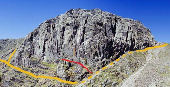
The red line is the first one you come to and should be avoided. The correct line is the yellow one. - If you miss the line then further down is the gully dropping down from the tarn. The base of this is at about 700m so constitutes the greatest descent and reascent between the two summits. From the tarn (in reality just a very small pool) a worn path with some repaired sections leads up the scree (MB-340) to the summit plateau. Turn left for the summit.
- Broad Stand
- Down and left of the col is a narrow chimney in the rockface. This is the start to Broad Stand. Squeeze through the gap to a platform. Most will require the assurance of a line (Rock gear needed) for the first two rock steps. After this the going is easy over the smooth slabs leading up right with the best line aiming to the left - it is well worn by climbers. The summit of Scafell lies around 400m away (MB-220).
- Lord’s Rake and West Wall Traverse
- Just before the point where the col of Mickledore meets the rock face turn right and drop down a short loose gully then keep to the foot of the crags as the path heads towards Lord’s Rake. The low point is at about 800m altitude. Head up the Rake to just below the first col where a terrace (The West Wall Traverse) leads leftwards into Deep Gill. Once in the Gill head upwards, generally easy if rocky, to a short steep scramble to gain the summit plateau. The summit is on a bearing of (MB-190).
Follow the steep path leading down the bowl (roughly MB-290, MB-247, then MB-310) eventually the angle eases and the edge of Rakehead Crag.
From here there are two options:
- The Corpse Road
- Maybe well named! Keep on the edge of the crags until the ground below you becomes grassier. Drop down to The Corpse Road (GR: NY18310669) that crosses over from Eskdale and follow it past Wasdale Head Hall Farm to Brackenclose.
- Lingmell Beck
- There is a scree run (GR: NY19450679) down towards Lingmell Beck. Take this, then the steep grass slope below, cross the beck just above the intake wall and follow the Scafell Pike tourist path down to Brackenclose.
Parking notes
⇅ Section Four: Wasdale to Honister Pass
This section is another tough section especially since it follows the long central section. It begins with another steep climb direct from the car park at Wasdale to the summit of Yewbarrow. Generally easy running ground then leads around the head of Mosedale over Pillar to Black Sail Pass. Kirkfell and Great Gable (which along with Green Gable is the last rough section) are then traversed before easier ground leads to Honister Pass.
Distance: 10 miles, Ascent: c.6300ft, Time 5hrs
Go out to the valley road, turn left along this and after about 100m there is a gate to the right marked “Private”. Go through this into the field and bear leftwards up to where the wall is replaced by a wire fence. There is a stile over the fence. Keeping the beck to the left go straight (or as straight as possible) up the fellside until beneath the final screes. Bear right towards a square boulder and gain a path through the screes and continue rightwards until a small cairn is reached. Now go directly up to the summit of Yewbarrow
Continue northwards along the summit ridge but do not climb onto the north summit, but bear left at a cairn on the broad col (GR: NY17430888) and descend a faint path to contour round to pass beneath the end crags of Yewbarrow and so to Dore Head (GR: NY17400956). This path is not marked on the current OS maps.
Take the well worn path rising on the other side of the col to gain the summit of Red Pike (GR: NY16391066). Continue along the ridge towards Scoat Fell. Do not head towards the summit but keep to the left just below the main areas of rocky ground - there is a path on the ground. This takes you to the wall along the edge of Ennerdale. The connecting ridge for Steeple starts at the point where the wall makes a sharp turn. Go out and back along this ridge. Now follow the old stone wall (leftwards) along the ridge past the top of Scoat Fell.
Continue along the ridge, at first on the Ennerdale side, then after the first col take the right-hand path which leads to a small cairn, move to the Wasdale side of Black Crag and follow grassy rakes with some scree to gain Wind Gap. The climb up from here is very rocky until it broadens and rises to the summit of Pillar. The going now gets easier on the long descent to Black Sail Pass (GR: NY191114)
Climb steeply up the rocky shoulder above the pass following a line of old fence posts to gain easier ground on the summit plateau of Kirk Fell. The summit is around 1/3 of a mile (MB-155), though it is as easy to continue to follow the old fence posts. From the summit head towards KirkFell tarn (MB-050) and pass it on the right to rejoin the main path. Now drop down to Beck Head via Rib End. Keep on a bearing of (MB-085) to take the path up Great Gable’s NW ridge. This is all very stoney but it is the last hard climb of the round.
From the summit of Great Gable descend the steep rocky path to Windy Gap and the short pull up to Green Gable. The going now becomes much easier.
From Green Gable follow the wide stoney track that leads down into Gillercombe, but after about 100m bear slightly left on another wide track. This becomes rocky as it drops to the tarns filling the col before Brandreth. The main path swings to the left but continue in a direct line for the summit of Brandreth. This way is grassier and easier going than the path.
Continue in a northerly direction, to cross a new fence at a stile. Follow the fence to Grey Knotts. The summit ridge is a rocky whale-back on the Borrowdale side of the fence, it is easiest to run along it than come in from the side. Back across the fence but do not follow it but go straight on before bearing left down a grassy trod. The ground steepens and goes down a spur. At the foot of this spur, head right along a path until a further spur drops down to the quarry road. Go through the buildings to the car park.
Parking notes
⇅ Section Five: Honister Pass to Keswick
This is the shortest fell section with only three summits to cross before the final road section is reached. Follow the fence up to Dale Head, there then follows a high level ridge over Hindscarth and Robinson before a long ridge is descended to the road. Generally grassy underfoot.
Distance: 10.6 miles, Ascent: c.2500ft, Time 3hrs
There is a wire fence leading from behind the youth hostel. Follow this for around 1 Km. Continue up the broad ridge of Dale Head. This is the last major climb of the round.
From the summit of this follow the narrowing rocky ridge (MB-286) that marks the head of Near Tongue Gill, at the narrowest point the path lies on the south side of the ridge. The summit of Hindscarth lies away from the main path so once you reach level ground take a good path leading rightwards to reach it.
Take a narrow track that leads down and right from just south of the summit (approximately MB-219 ). This almost joins the main path at LittleDale Edge. At this point keep parallel to the main path until the slopes of Robinson begin to broaden, bear right to reach the summit of Robinson (The last top!!).
Take the NE ridge, there are two options: either drop down on the eastern side of this just before a steepening. Follow the path down to Scope Beck, with a steep section just before the valley floor. The track leads along the valley bottom to High Snab (GR: NY221189). Alternatively: keep on the ridge (there is a rock step when level with the dam in the valley) until just before the intake wall it is possible to drop down right to the track. The remainder back to Keswick is on tarmac roads.
Go down the farm track, keeping right at the first junction and straight ahead at the second (by a chapel) to (GR: NY231193). Pass through Little Town and continue to Stair.
Straight over the cross-roads to the pub at Swinside. A short climb through the woods leads to an undulating descent to Portinscale. Turn right at the chapel in Portinscale and go down the road to cross the river via a footbridge.
After a short distance take the footpath on the right across fields then playing fields to enter Keswick close to the museum. Turn right and follow the main road to the bottom of the market square. Take the last climb to the Moot Hall. Well Done!
⇅ Keswick to Honister
This is the shortest fell section with only three summits to cross following the only real road section on the round. Roads through Portinscale, Swinside, Stair and Little Town lead to a long climb to Robinson, then a high level ridge over Hindscarth to Dale Head, and then down to the road. Generally grassy underfoot.
Distance: 10.6 miles, Ascent: c.2500ft, Time 3hrs
From the Moot Hall head down the market place and along the road. Just after you cross the River Greta there is a footpath to the left. Take this through the fields to join a disused road leading to the footbridge back across the Greta into Portinscale.
In Portinscale turn left and follow the road to Stair. (go right at the junction in the woods, left/straight on at Swinside) In Stair bear left to Little Town and keep going to the chapel. Take the farm track on the left which leads to the open fell.
Follow the track along the valley floor until just before the dam. Bear right up the steep slope onto the ridge. Go left and scramble up the rocks before the path follows the NE ridge to the summit of Robinson. Now head east down broad slopes to Littledale Edge.
As the ground begins to rise there’s a path that rises to the left and leads almost to the summit of Hindscarth. From the summit head south then east to follow the narrow ridge up to Dale Head
Follow the prominent path south that leads down wide slopes to the slate mines at Honister.
Parking notes
⇅ Honister to Wasdale
This first of the tough sections. Good running as far as Green Gable then rough ground over Great Gable and Kirkfell. A long pull to Pillar is followed by mixed ground around the head of Mosedale before a big drop from Red Pike and an even bigger one from Yewbarrow directly into Wasdale.
Distance: 10 miles, Ascent: c.6300ft, Time 4hrs
Follow the fence line up the slope to the summit of Grey Knotts (the actual summit is to the east of the fence). Using the fence as a guide head towards Brandreth.
Open grassy ground leads to Green Gable. The rocky ground starts here. Drop into Windy Gap and begin the pull up to Great Gable.
Head westward across the stony summit plateau to pick up a path that zig-zags down to Beck Head.
A short pull on to Rib End then easier ground past Kirkfell Tarn leads to the summit of Kirk Fell. Head roughly NNW (MB-335) to the rocky shoulder that drops towards Black Sail Pass.
There are a couple of lines to take but all have loose rock so take care not to knock anything onto party members below. Once at the foot of the rib follow the old fence line down to Black Sail Pass
From Black Sail Pass it is a long grassy climb with the occasional rock sections to negotiate to the summit of Pillar. Now head SW to Wind Gap. Skirt Black Crag via the Wasdale Fell Race route on the Mosedale side to easier ground.
Keeping the big drop into Ennerdale on your right, continue until the out and back path to Steeple is reached. This one of the narrower sections of ridge on the round so take care.
Skirt Scoat Fell by grassy slopes to the south. The main path doesn’t visit the summit of Red Pike so a minor detour is required. The path now begins to drop steeply towards Dore Head.
Don̵t climb the steep rocky face of Stirrup Crag that faces you but traverse rightwards until a path cuts up through the scree to a broad saddle on the ridge. Go right along easy ground to the summit of Yewbarrow.
There now follows a direct steep drop into Wasdale. Head east then begin to turn southwards as the ground steepens. Head towards a shallow gill that is in line with the end of Wastwater. Keep to the true left bank until a stile is reached that allows entry to the field. Head left to find the field gate. Turn left on the road then right to cross Wasdale Beck and to the Brackenclose car park.
Parking notes
⇅ Wasdale to Dunmail Raise
This is the longest section and also the roughest underfoot. The biggest climb of the round takes you onto Scafell. A choice of routes leads to Mickledore, from here the roughest section of the round takes you over Scafell Pike, Broad Crag, Ill Crag, Great End, Esk Pike and Bowfell. A steep drop leads to Rossett Pike then easier running over the Langdale Pikes and High Raise eventually leads to a steep descent from Steel Fell to the road at Dunmail Raise.
Distance: 15.2 miles, Ascent: c.6500ft, Time 7hrs
This is the biggest climb of the round. There are really two viable options:
- Follow the main tourist path to Scafell Pike path alongside Lingmell Gill, cross it and head up Brown Tongue (the modern path keeps to the south side of the tongue) to reach Hollowstones. Gain the foot of Lord’s Rake and either follow this in its entirety or take the West Wall Traverse into the upper reaches of Deep Gill.
- Take the old corpse road past Wasdale Head Hall Farm and onto open ground then cut back NE to follow the edge of the escarpment above Rakehead Crags. Follow more distinct paths to the saddle between Symond’s Knott and Scafell, thence to the summit.
There are now three options to reach Scafell Pike, none easy.
- Deep Gill then the West Wall Traverse to Lord’s Rake. The top few metres of Deep Gill is a scramble down to a stoney bed. WWT is mildly exposed, Lord’s Rake has been denuded of scree for many years. Once at the foot bear right under Scafell Crag to Mickledore.
- Broad Stand. This will need someone to have fixed a safety line in place. From the saddle head over Symmond’s Knott to a series of slabs that fall away to the right. Pick your way down these until the ground drops away, Broad Stand is now directly between here and Mickledore.
- Foxes Tarn. Go east from the saddle and descend steps to the tarn. Follow the outflow down a gully and from here head back up to Mickledore. This has the most descent and reascent but is probably preferable in this direction.
From Mickledore go past the MRT stretcher box and follow the very rocky path to the summit of Scafell Pike. Drop down to the col beyond and scramble over rocks to reach Broad Crag. Gaining Ill Crag is only slightly less rough.
Rejoin the main walkers’ path and follow it until it begins to descend into Calf Cove. Keep on the high ground to reach Great End. More rocky ground now leads due east down to the upper col of Esk Hause
Easier going leads up to Esk Pike before more roughness returns on the descent to Ore Gap.
A grassy line may be found avoiding the main rocky path until just before the summit cone of Bowfell. Head north past the summit of Bowfell Buttress until the top of the rakes on the Langdale face may be located. (Quite tricky on first acquaintance)
Descend the rakes with care - there’s several options - but all lead to a large shallow grassy gully that parallels Rossett Gill. (Reliable water spring at the foot of this gully) Traverse leftwards to the top of Rossett Gill.
Easy going reaches the summit of Rossett Pike. Continue on the broad summit ridge until you drop into a large gap. Cut right to take a faint track that contours the Langdale face of the fell and which leads to the outflow of Langdale Combe.
A short pull leads to boggy ground over Martcrag Moor.
As the ground rises from Martcrag Moor the main walkers’ is picked up. Follow this to Pike o’ Stickle. Scramble up to the summit and back.
Obvious paths now lead behind Loft Crag to the top of Dungeon Gill.
There’s a steep pull to the summit of Harrison Stickle. Easier ground now leads over Thunacar Knott. The next two tops may be visited in either order.
- Continue in the same line via an obvious path that leads to the summit of High Raise. Head SW on good running ground to Sergeant Man. Now go NW to pick up the valley containing Mire Beck and follow this down to the head of Easedale.
- Continue in the same line until a path is seen contouring round to the right. Take this to Sergeant Man from where good running heads NE to High Raise. Vague ground now leads NW to Birks Gill which drops down to the head of Easedale.
Easy ground leads to Calf Crag. From here the going gets increasingly boggy, the line is to the south of an old fence, before climbing up to Steel Fell.
From the summit head N until a path bears right and drops steeply to the road at Dunmail Raise.
Parking notes
⇅ Dunmail Raise to Threlkeld
A harsh series of big pulls over Seat Sandal, Fairfield and Dollywaggon Pike give access to the Helvellyn ridge. The going is now mainly grassy with some easy stony paths around Helvellyn. A big drop from Clough Head leads to Threlkeld.
Distance: 13.2 miles, Ascent: c.5900ft, Time 4hrs
Cross the road (carefully!) and follow the path alongside Raise Beck. At the point where it enters the gulley take a path up the shoulder to the right. This is steep at first but begins to ease with height.
Keep climbing the broad slopes until things become rockier. Now bear leftwards to the summit of Seat Sandal. The path down to Hause Gap is stoney but apart from a rocky step is straight forward.
The climb up to Fairfield isn’t pleasant being mostly loose scree. Eventually it eases and the summit plateau leads to a low shelter around the summit cairn. There are now two options:
- Return to Hause Gap via the route of ascent and then traverse the slopes of Seat Sandal to the broad area at the head of Raise Gill.
- Go over Cofa Pike to Deepdale Hause and take the path down to the outflow of Grizedale Tarn.
Either option leaves you at the foot of a steep climb but both arrive at a gateway in an old fence line. From here it is a short distance to the summit of Dollywaggon Pike.
Straightforward running now leads over Nethermost Pike to Helvellyn.
From the trig point on Helvellyn keep the drop on your right and follow easy ground to Helvellyn Lower Man. The descent from here is rocky and steep.
Once at the foot of the ridge easy ground leads to White Side.
From White Side easy ground leads to the stony summit area of Raise. Drop down to the summit of Sticks Pass and take the path straight ahead to Stybarrow Dodd.
The summit of Stybarrow Dodd is rocky but once away from this it is very easy ground first to Watson’s Dodd and then to Great Dodd.
The easy ground continues, if a little steeper, past Little Dodd and Calfhow Pike to Clough Head.
Continue NE along the summit ridge until a path drops steeply down the northern slopes. This leads directly to the Old Coach Road.
Go directly over the track and follow the fence line northwestward (keep it to your right). The fence leads to woods surrounding Threlkeld Quarry.
Go through the gate and make a line for Newsham House. Turn left and follow the lane down to the A66.
Parking notes
⇅ Threlkeld to Keswick
The last big climb up Hall’s Fell to Blencathra. Moorland running over Mungrisedale Common to Great Calva and finally Skiddaw. A massive descent on tired legs leads to a bridge over the A66 and gentle running back to the Moot Hall.
Distance: 12.5 miles, Ascent: c.5150ft, Time: 4hrs
Cross the A66 with care and take the road into the village. At the junction take the right hand road leading up the hill.
Just after the council depot take the farm track on the left. Go through the farm and exit onto open land. The path up Hall’ Fell starts over the beck to the right.
The climb up Hall’ Fell is steep but steady and presents little difficult until the last 100m or so when it becomes very rocky and particularly slippy in the wet.
The ridge end directly at the summit of Blencathra. Now head northwards towards Atkinson Pike but before reaching that point bear left across scree and then follow a path across Mungrisdale Common. There are now three options:
Note that the next section may be subject to change as the tree planting as part of the Skiddaw Forest rewilding project. The proposed area covers the route from the River Caldew, over Great Calva untils about 1km beyond Skiddaw summit. Any on-the-ground directions should be followed in preference to these notes.
- From the summit cairn of Mungrisdale Common head SW to the Cloven Stone then descend directly westwards and cross boggy ground to pick up the bridleway leading to Skiddaw House. From here follow the vehicle track until a path on the south ridge of Great Calva may be located and followed to the summit. This is the best option after heavy rain.
- From the summit of Mungrisdale Common head directly towards Great Calva. This is becoming increasingly heathery.
- Head north to the confluence of the River Caldew and Wiley Gill. Cross the Caldew and follow Wiley Gill until a fence line is reached. Follow this up the fellside to the summit. May be impassible after heavy rain.
From the summit of Great Calva head south to follow a path alongside Dead Beck to the Skiddaw House access track.
From the track boggy ground leads to Hare Crag. Go over this then follow a path up the slopes of Skiddaw to reach a stile in the fence.
Over the stile and join the walkers’ path leading to the summit of Skiddaw. Continue in the same line across the summit area and follow the tourist route down to the car park at Latrigg.
Opposite the car park is a gate leading to a good path that descends the slopes of Latrigg. It crosses the A66 by a bridge. When it meets the road, turn right, in a couple of hundred metres take a gate into Fitz Park.
Go through Fitz Park and cross the River Greta by a footbridge. Cross the main road and the car park to enter Keswick market place and the Moot Hall. Well Done!