The Bob Graham Round
As a Lakelander, I have long had interests in the area outside climbing. One of these is the 24 hour challenge, the Bob Graham Round. It is not a race, except against the clock, and contenders may attempt the circuit in either a clockwise or an anti-clockwise direction.
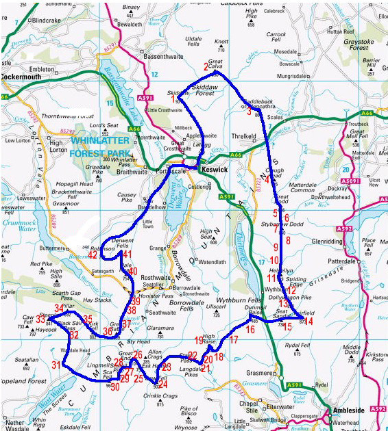
The challenge is naturally divided by four road crossings into five sections. In a clockwise order these are:
- Keswick to Threlkeld over Skiddaw, Great Calva and Blencathra
- Threlkeld to Dunmail Raise over the Helvellyn range.
- Dunmail Raise to Wasdale over the central Lakeland fells including Scafell Pike.
- Wasdale to Honister Pass over the Wasdale skyline including Pillar and Great Gable.
- Honister Pass to Keswick over the Robinson group then 5 miles of road to finish.
Traditionally the Bob Graham Round was reckoned to be around 72 miles. However using modern mapping software gives a distance of between 61 and 63 miles depending on the software being used. Contenders who have taken GPS units have recorded distances between 65 & 66 miles (105 - 106 km). Interestingly, the traditional given height gained for the round of 26,000 ft (7950m) is confirmed by the same sources.
The “rules” such as they are:
- Start at the Moot Hall in Keswick.
- Traverse the 42 summits on foot.
- Return to the starting point within 24hrs of starting.
If you wish to become a member of the Bob Graham Club there is one further requirement:
- your attempt must be witnessed at each summit.
The full history of the Round, including earlier progressions in the Lakeland 24hr record may be found in the Bob Graham Club’s booklet “42 Peaks”. The current edition is written by Peter McDonald who has his own website with information about the Round.
By default the information presented here relates to a clockwise round beginning at midnight on the closest Saturday to the next midsummer (this will be ). If you wish to change this then open the calculator dialog via the button at the RH end of the menu above, pick your settings and save them.